" south park "
...Caution...
Truth
Plainly Spoken , the following link could have devastating effects for the faint of heart.
As the rendering of information;
contained within, could quite
possibility result in irregular heartbeat
hearing South Park many urban legends, and not how it really was.
I do not gift wrap my words, I deal in fact and truth.
Historically Speaking...
Cabintown,
chronologically
could loosely be a part of South Park, in that the name South Park grew out from a part of Cabintown,
with Cabintown being anything that was south of Third Street...
"A
bitter rivalry existed between the parts of the town divided by Third Street.
People living north of Third Street appropriated the name of Dayton to
themselves, and in derision called that part of the town lying south of that
street Cabintown.
When it was proposed to remove the market from Second Street to the present
location, violent opposition was made and every measure resorted to defeat it.
Two tickets were nominated for city officers, politics were forgotten, and this
was made the sole issue.
Cabintown proved numerically the stronger and the fate of the market
house was sealed. When the market house was moved, Thomas Morrison, who had it
in charge, placed a large placard on it, "Bound for
Cabintown," which
was read with the deepest chagrin by the people on Market, now Second Street. So
bitter was the feeling that for a long while, many persons refused to attend
market at the new location. William Clark was appointed clerk and marshal of the
market by council in 1830. His salary was seventy-five dollars per annum."
"History of
Dayton, Ohio, H. Crew; 1889, pg. 159."
Dayton's neighborhoods each had their selective nicknames like most early cities tended to have and still do, names such as McPherson Town, Africa, Belmont, Edgemont, Mexico, White City, as well as a Slidertown which was commonly thought to be in what we know as the Historic South Park area. It isn't of course, the following is how I came about to discover that Slidertown just kissed the edge of the Historic South Park property line, or Outlots. In my dreamy pursuit of an inner-city dog park, that I would like to have located to the rear of the old Emerson School, right were the Route 35 walk over bridge; which just happens to bridge and connect two historical districts the Oregon Historical district, and Historical South Park. I naturally had to give this dream dog park a name since, after all this was my idea and the City wasn't busting a grape to move on it, I elected on calling it "Slidertown Dog Park," since local rumor has South Park being called Slidertown or a part of, I elected to find just where Slidertown was located to be accurate, which any practical analytical person would do. Now is the time to thank all of the people in the Montgomery County Records Office, the Montgomery County Records Center and Archives (Tina Ratcliff), Super Dave Neuhardt and Curt Dalton couple of Dayton's good guys, as this research project would not have been possible with out their patience and understanding of my thirsty inquisitive mind.
I
referenced mention of a Slydertown in the "B-Hoy" a very early weekly
newspaper, my copy dated March, 1848 http://www.communicationart.net/B-Hoy/B-Hoy.pdf
, I have to date found one other mention of a Slyder,
that being when one Bessie Slyder
whom was to
be married.
Centennial Portrait and Biographical Record of the City of Dayton and of Montgomery County,
Ohio
Pages 1232-1244 Thomas Gilbert
to Joshua Swartzel
Here is a quote from the
application of lie's and falsehoods on South Park becoming historical in 1978:
http://www.daytonohio.gov/departments/pcd/planning/City%20of%20Dayton%20Historic%20Districts/South_Park.pdf
That reads:
Platted in the mid-1800's the
area which would later become South Park was original called "Slidertown"
Ironically it named after an early, and otherwise, unremembered Dayton minister,
the Reverend Slider. During the 1880's in Dayton, it was commonly said that
"everything bad in town slide down to Slidertown". Histories describe Slidertown
as a collection of shacks and ramshackle house in open areas reaching from Main
to Brown Streets and south from Wyoming Street.
I have no idea who comes up with these falsehoods, urban legends, or as I call
it lie's. I wanted to expose and bring truth to the neighborhood on the origin
of Slidertown; sort of like an Historical Detective, as what is being stated is a
misleading lie, apparently South Park Patrol is concerned more about physical
stealing and not temporal stealing, where I place equal value on both subjects,
but then I would. I commented on my thesis on the origin of Slidertown, on Facebook's,
South Park
Patrol.
With Mark
Echtney responding to my post:
Hi Larry, just
letting you know this facebook group is only for the reporting (sometimes
venting) of crime in the neighborhood. I set it up specifically for people to
have a private place to report and share information - it isn't here for any
other neighborhood topics, thanks
Free me from error, but is not lying or spreading rumors a civil crime (politician's exempted), I know when I catch someone in a lie to me, I cut them loose, and have no faith in anything they would ever say to me again, and stay as far away from them as possible. I made up a word (I think I did anyway) of when someone lies to me, I call them a "Dick Breath," as they are trying to screw me in the ear with their sound pressure levels, and fundamental frequency's.
I contribute
Slidertown to
one Elijah Slider who married one Margaret Koogler on the Third day of May, 1816 ,
with Slider's name being bastardized into Slyder (I assume absurdity he
was Sly; or the fact he was the inventor of the world famous Slyder Hamburgers,
we know as of today), which in time became Slydertown before it became Slidertown. I am
sure because of the many properties he owned, which for all intent and purposes
was:
Outlot 26, 29, 30, 67, and 70, though he in fact had other properties,
these Outlots is what I contribute to the Slidertown neighborhood.
As supported in my research (open link below)
Origin of Slidertown
As you can clearly read,
Slider Town was never in the Historic South Park district as our would be Dilettante South Park
Historians may want one to believe.
The South
Park area happened to give birth to its identity as reported in The N. C. R.,
Making Division, on December 15th, 1895, page 567,
by the Editor Frank Bickford:
Some fifty
employees of the Factory living near the plant, have organized a social club
called the "South Park Club." The first officers are Mr. Frank Radford,
President; Mr. R. T. Houk, Vice President; Mr. Grant Gibson, Secretary; Mr.
George Grove, Treasurer; Messrs. John Dohner, F. H. Bickford, Walter Bell,
George Gardiner, and S. Mountain, directors. For the present the club rooms will
be open Monday, Wednesday and Friday evenings, and Sunday afternoons. The club
has great plans for the future.
To take the Origin of South Park Further
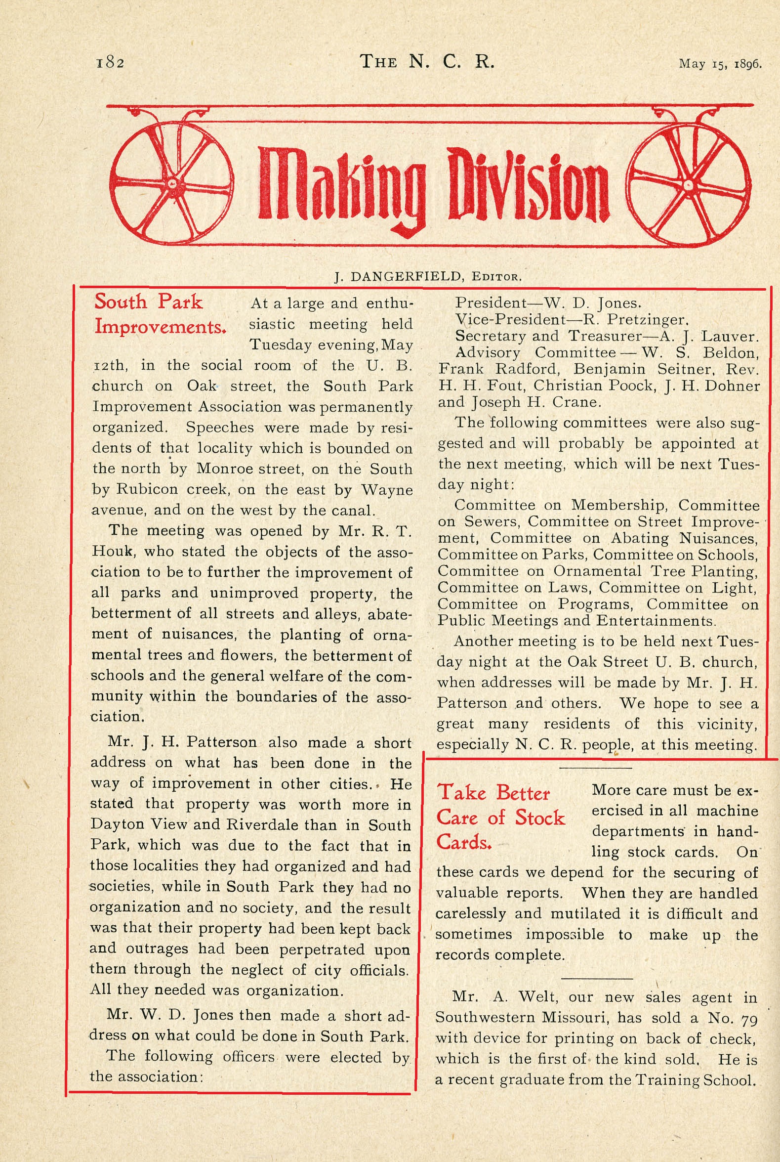
The N. C. R., Making Division, on May 15th, 1896, page 182, by the Editor, J. Dangerfield.
Tuesday evening, May 12th, in the social room of the U. B. church on Oak street, the South Park Improvement Association was permanently organized. Speeches were made by residents of that locality which is bounded on the north by Monroe street, on the South by Rubicon creek, on the east by Wayne avenue, and on the west by the canal.
The meeting was opened by Mr. R. T. Houk, who stated the objects of the association to be to further the improvement of all parks and unimproved property, the betterment of all streets and alleys, abatement of nuisances, the planting of ornamental trees and flowers, the betterment of schools and the general welfare of the community within the boundaries of the association.
Mr. J. H. Patterson also made a short address on what has been done in the way of improvement in other cities. He stated that property was worth more in Dayton View and Riverdale than in South Park, which was due to the fact that in those localities they had organized and had societies, while in South Park they had no organization and no society, and the result was that their property had been kept back and outrages had been perpetrated upon them through the neglect of city officials. All they needed was organization.
Mr. W. D. Jones then made a short address on what could be done in South Park.
The following officers were elected by the association:
President — W. D. Jones, Vice-President — R. Pretzinger, Secretary and Treasurer — A. J. Lauver, Advisory Committee — W. S. Beldon, Frank Radford, Benjamin Seitner, Rev. H. H. Fout, Christian Poock, J. H. Dohner and Joseph H. Crane.
The following committees were also suggested and will probably be appointed at the next meeting, which will be next Tuesday night:
Committee on Membership, Committee on Sewers, Committee on Street Improvement, Committee on Abating Nuisances, Committee on Parks, Committee on Schools, Committee on Ornamental Tree Planting, Committee on Laws, Committee on Light, Committee on Programs, Committee on Public Meetings and Entertainments.
Another meeting is to be held next Tuesday night at the Oak Street U. B. church, when addresses will be made by Mr. J. H. Patterson and others. We hope to see a great many residents of this vicinity, especially N. C. R. people, at this meeting.
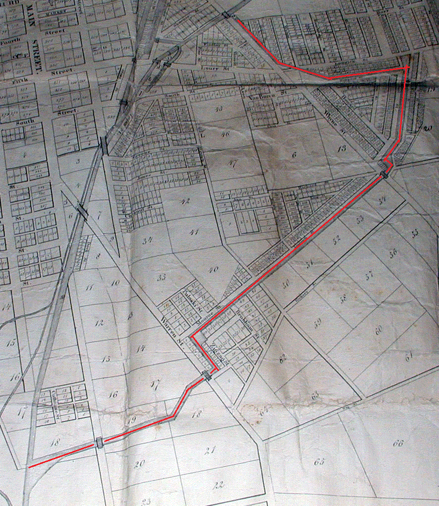
Maps to show the Boundaries of the original South Park
which was Monroe Street to the north, the Miami Canal to the west, Wayne Avenue
to the east, and Rubicon Creek to the south.
Open maps below
Monroe Street Miami Canal Wayne Ave Rubicon
Creek
The farm land south of
Seely's
Canal (1828), later a ditch that we now call Burns Avenue,
http://www.communicationart.net/Map_1839/whole_SeelysDitch.gif Here I have
displayed for your viewing enjoyment; what Van Cleve had drawn in his 1839 map
(map thanks to Dave Neuhardt, one of the good guys). The Black people lived
around:
http://daytonology.blogspot.com/2008/02/geographlical-take-on-dayton-black.html
that is right, the
South Park area was also called
Africa (located at Wayne Avenue and Burns) as we know it today. The progression
from farm land to residential living has had many groups of people living within
its boundaries, the first settlement of people of color was in South Park. South
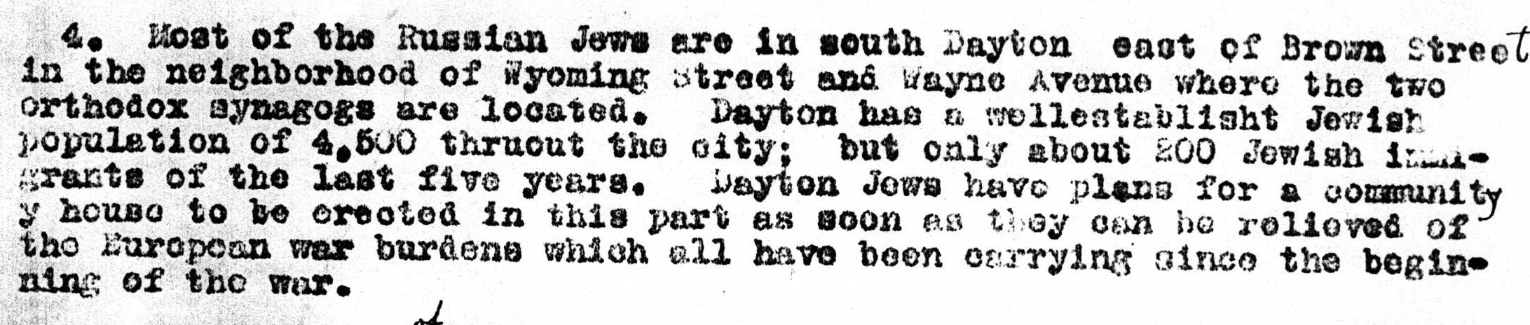
Park as time progressed became a Jewish neighborhood.
"Foreigners of Dayton an
Investigation,"
Census of 1910.
By Alice M. Doran; Pg. 4.
South Park later on in time; became a working class neighborhood from the abundance of work at such factories such as NCR, DELCO, FRIGIDAIRE to name a few there was a wealth of big time major companies that engulfed the city of Dayton at one time. From the canal days up to just a few short years ago, Dayton was always a major player in the industrialization of the U.S. of A.. The 1913 flood resulted in people wanting a safer neighborhood to live in; with a lot of people entertaining the South Park neighborhood, as the flood waters just happened to reach the bottom of Herman Street hill, (now Burns Avenue).
The factory production for the war effort was tremendous, we have the First World War production of Dayton-Wright Airplanes that the Army never bought (are you ready for that dear reader?), then the Second World War we had as an example the Enigma program, which was operated by the Wave's, under the aegis of Joe Desch. With all of the industry and people from around the country looking and finding work, a lot of the South Park homes became rooming houses, duplexes, and doubles. As an example Franklin Runyon Sousley who lived at 107 Park Drive in a small apartment, whom happened to be one of the six men, though four are visible, that raised the flag on Iwo Jima in WW II.
With the introduction of bussing, the educated class and the "Don't confuse me with facts, I got my mind made up people..." of the neighborhood (they thought) moved to the suburbs, the advent of Route 35 from Interstate 75 resulted in the busting up of two good neighborhoods (Burns Jackson now Oregon; and South Park) majority of the people migrated to Huber Heights, now commonly referred to as Huber-tucky. In time cities across the country set up a wave of Historical Districts, the City of Dayton joined the bandwagon, with South Park being granted the honors of a Historical District, then the formation of a perseveration society that today is referred to commonly as Historic South Park Inc.. or as it is more commonly referred to as Hysterical South Park
South Park has had it problems in the past, but what neighborhood doesn't or hasn't? The smell of making some bucks from sweat equity and buying on the cheap made Historical Districts more than attractive, or so we thought at one time, the market today is something else. The slumlords sold to people that took multiple family home's and brought them back to a one family residency. This has developed into a rather charming and rich scenario, as the majority of people that reside within our historical boundaries want a nice comfortable place to call home combined with a neighborhood that is reflective of their personalities, and for the most part the neighborhood is warm, open, and friendly. South Park does its Porch and Patio thingy, which is a great way to get away from your everyday grind and socialize in a civilized manner, since the crude, primitive, and barbaric people have either died, are in jail, or have moved out, leaving just us people of distinguishing characteristics. We just happen to have a two step Dayton Marble carriage stone to the front of our house (212 Bonner Street) (one of only four in Dayton), which has become for the children a gathering and sitting place to rest and gather some shade and their breath. We get a kick out how the little kids will run to see who can get to sit down first, while the parents lean and rest on our limestone retaining wall that I rescued from Miami Valley Hospital, that had torn it down for its expansion.
South Park becomes Snob Park

http://daytonology.blogspot.com/2007/10/south-park-plats-through-1870.html
http://daytonology.blogspot.com/2007/10/south-park-urban-morphology.html
http://daytonology.blogspot.com/2007/10/south-park-corner-store-o-rama.html
http://daytonology.blogspot.com/2008/02/geographlical-take-on-dayton-black.html